< Convective Parameters and Indices | Meteorology | Structure and Evolution of Squall Lines and Bow Echos >
Also see: Chase-Casting Science
Structure and Dynamics of Supercell Thunderstorms
The following information was copied from the Louisville KY WFO website on 2011-04-18.
Any errors are my fault.
PAGE CONTENTS
DIFFERENT THUNDERSTORM TYPES
DYNAMICS OF SUPERCELLS; ENVIRONMENTAL CHARACTERISTICS
TORNADO MECHANISMS IN SUPERCELLS
WSR-88D REFLECTIVITY SIGNATURES ASSOCIATED WITH SUPERCELLS
MESOCYCLONE SIGNATURES ASSOCIATED WITH SUPERCELLS
GUIDANCE FOR WARNING DECISIONS FOR SUPERCELLS
Supercell thunderstorms are perhaps the most violent of all thunderstorm types, and are capable of producing damaging winds, large hail, and weak-to-violent tornadoes. They are most common during the spring across the central United States when moderate-to-strong atmospheric wind fields, vertical wind shear (change in wind direction and/or speed with height), and instability are present. The degree and vertical distribution of moisture, instability, lift, and especially wind shear have a profound influence on convective storm type, including supercells, multicells (including squall lines and bow echoes), ordinary/pulse storms, or a combination of storm types. Once thunderstorms form, small/convective-scale interactions also influence storm type and evolution. There are variations of supercells, including "classic," "miniature," "high precipitation (HP)," and "low precipitation (LP)" storms. In general, however, the supercell class of storms is defined by a persistent rotating updraft (i.e., mesocyclone) which promotes storm organization, maintenance, and severity. More information concerning environmental conditions and the structure of classic and HP supercells is given below. WSR-88D Doppler radar imagery showing the evolution of some supercell events across Kentucky and south-central Indiana are available.
DIFFERENT THUNDERSTORM TYPES
| Ordinary: Short-lived (30-60 minutes) storm; generally is non-severe but pulse severe storm is possible; storm moves with mean wind; little or no vertical wind shear/weak winds aloft in environment; chaotic hodograph (right); typical in summertime; buoyancy process important. | 
|
| Multicell: Group of cells in different stages of development; can be severe or non-severe; often move with the mean wind; show discreet propagation with new cell growth on the unstable inflow flank; weak-to-strong environmental wind shear/winds aloft; usually a "straight-line" (unidirectional) hodograph indicating speed and/or directional shear conducive for MCSs, squall lines, and bow echoes (right); gust front process important (balance between convectively-induced low-level cold pool strength and depth under the heavy rain and the ambient low-level wind shear) to trigger new cells. | 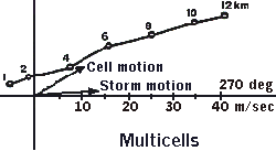
|
| Supercell: Large severe storm occurring in a significant vertically-sheared environment; contains quasi-steady, strongly rotating updraft (mesocyclone); usually moves to the right (perhaps left) of the mean wind; can evolve from a non-supercell storm; moderate-to-strong vertical speed and directional wind shear in the 0-6 km layer; usually a "curved" hodograph in the lowest 0-3 km and a straight line above (right); dynamic process important resulting in a steady-state storm. | 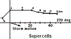
|
| Hodographs showing vertical wind shear for ordinary, multicell, and supercell thunderstorms. Dots along hodograph line represent end point of arrowheads of vectors (not shown) originating from (0,0) point (x/y-axis intersection) that reveal wind speed and direction at the indicated height (in km). For example, on supercell hodograph, winds at 1 km altitude are from the southeast, stronger from the south at 2 km, with winds increasing in speed (longer vectors from (0,0) point to each dot) and veering to southwest at higher altitudes. The longer the hodograph, the greater the vertical wind shear. Not only length, but shape of hodograph is important. For example, straight-line hodograph for multicells and curved hodograph for supercells both indicate speed and directional shear. However, curved hodograph indicates presence of a low-level wind maximum (jet) which increases storm-relative flow into storm and potential for supercell development. Supercells can evolve from straight-line hodographs as well but are more common with curved hodographs. In contrast, only weak shear is shown for ordinary cells, although if high instability is present, then a severe pulse storm can occur, with hail and/or brief damaging winds. | |
DYNAMICS OF SUPERCELLS; ENVIRONMENTAL CHARACTERISTICS
Supercells are not defined by their depth or volume. They can be large or small, high-topped or low-topped, and can occur anywhere, including the Ohio Valley. They are most common in the central United States. While supercells are not as common as other convective types, they often produce violent weather.
The interaction between updrafts and the vertically-sheared environment strongly controls the degree of organization and severity of convection. Supercells and tornadoes are associated with moderate-to-strong vertical wind shear (and helicity) and moderate-to-high CAPE (instability) (see figure below). Rough total wind shear threshold for supercells is 40 kts (20 m/s) in the 0-6 km layer. To determine this threshold, look at the length of the hodograph (which includes speed and directional shear) in this layer, and "lay out" the hodograph along the x-axis to see if it exceeds 40 kts. If so, supercells are quite possible; if not, supercells can still occur given some shear and high CAPE values.
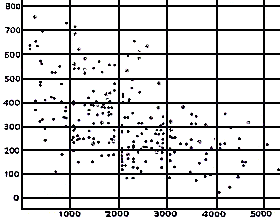
| Scatter plot of strong and violent supercell tornadoes with respect to 0-2 km helicity (y-axis) values in m2/s2 and CAPE (x-axis) in J/kg. Major tornado outbreaks typically associated with moderate-to-high CAPE (1500-3500 J/kg) AND helicity (150-450 m2/s2). Isolated to scattered tornadoes associated with low CAPE and high helicity (upper left part of plot). Scattered tornadoes associated with high CAPE and low helicity (lower right part of plot). |
Strong 0-6 km shear (long hodograph) causes high helicity/high potential for supercell and mesocyclone (rotating updraft) development, but NOT necessarily tornadoes. Mesocyclone strength also is dependent on buoyancy. Tornado development is dependent on dynamical structure in the storm. Generally, a supercell/mesocyclone occurring in an environment with significant low-level (0-2 km) curvature in the hodograph (indicating the presence of a low-level jet) is conducive to tornado development.
Vertical wind shear causes the development of dynamic processes in the storm which affect the evolution, strength, longevity, and motion of the supercell. Explanation: 1) Environmental shear results in a rotating updraft as horizontal vorticity is titled vertically into the updraft. 2) The diagnostic pressure equation states that rotation about a vertical axis (rotating updraft) must be balanced by a pressure gradient force pointed toward the center of rotation causing lowered pressure in the middle-levels of a storm where the rotation/updraft is strongest. 3) This vertical pressure perturbation leads to an even stronger updraft into the middle-levels, which in turn causes even more rotation (due to vertical stretching) as the updraft speed increases with height, which in turn can feed back and cause an even stronger middle-level pressure perturbation. The deeper the environmental wind shear, the more efficient the dynamic process should be.
This dynamic process results in an enhanced steady-state updraft; dynamic forces are as important or even more so than buoyancy forces in supporting updraft strength and rotation. The supercell actually can "suck up" air and continue well into night despite the loss of heating, weaker instability, and dissipation of ordinary cells. The dynamic process also causes high (low) pressure on the upshear/downdraft (downshear/updraft) side of the storm, which results in storm tilt and a right movement of the storm compared to the mean wind.
Dynamic forces eventually can cause the main updraft to split into 2 separate updrafts, i.e., each supercell can develop both cyclonic (on the right flank) and anticyclonic rotation (on the left flank) in the middle-levels. This can cause the storm to split into 2 separate cells, one moving right and the other left of the mean wind. For a right (left) moving storm, the cyclonic rotation is within the updraft (downdraft) and the anticyclonic rotation is within the downdraft (updraft) with the tightest reflectivity gradient on the south/east (north) side of the storm coincident with the updraft. A classic example of a splitting storm occurred on May 28, 1996 over south-central Indiana. The right mover evolved into a classic supercell that produced several tornadoes.
Consider hodographs in evaluating the potential for storm splitting and which cell will dominate. A straight-line hodograph (unidirectional shear) is more conducive for storm splitting than a curved hodograph in the lowest few kilometers. Assuming a split occurs, a hodograph with significant curvature (clockwise turning to the shear vectors) in the low-levels promotes a strong right and weak left moving supercell.
The storm relative inflow direction and magnitude are very important. This determines which storm(s) will remain strong/severe. For example, if 2 cells are aligned north-south, both can remain strong despite ground-relative southerly inflow if the storm-relative inflow has an easterly component. Strong inflow speeds promote a stronger updraft strength and more rotation. Strong middle-level storm-relative flow into the supercell also seems to correlate with a strong mesocyclone capable of tornadogenesis in the low-levels.
TORNADO MECHANISMS IN SUPERCELLS
Nearly all supercells produce some sort of severe weather (large hail or damaging winds) but only 30 percent or less produce tornadoes. Thus, one must try to differentiate a tornadic supercell from a non-tornadic one.
In the environment, strong 0-6 km shear (long hodograph) and ample buoyancy is needed to generate a significant storm mesocyclone. Then, the supercell/mesocyclone occurring in an environment with significant low-level (0-2 km) "curvature" in the hodograph seems to be conducive to tornado development.
However, tornado development is dependent on the dynamical structure in the storm. There must be a strong updraft and source of vertical vorticity for strong mesocyclone and tornado development. Environmental horizontal vorticity caused by ambient vertical wind shear is critical to form a rotating updraft (mesocyclone). The environmental vorticity may be crosswise or streamwise.
However, tornado formation appears to be related to a storm scale process: the vertical tilting of baroclinically-induced horizontal vorticity. This process occurs along an outflow boundary associated with the forward flank downdraft (see figure below). Along this boundary in or near the low-level hook region on radar, a small-scale circulation occurs as warm environmental air rises on the warm side of the boundary while cold air sinks and undercuts on the cold side, which generates streamwise horizontal vorticity along the boundary (note the sense of rotation in figure below). This vorticity then is tilted and rapidly accelerated vertically into the storm updraft as the middle-level mesocyclone dynamically "sucks up" low-level air, resulting in a more prominent low-level mesocyclone and likely tornadogenesis. This process sometimes can be seen visually as a tail cloud moving into the hook area from the east, and may be visible on the WSR-88D reflectivity/velocity as an outflow boundary or fine line echo.

| Thunderstorm-scale schematic of a supercell-environmental interaction, that can result in the creation of vertical tilted baroclinically-induced horizontal vorticity. This can lead to enhancement of the low-level mesocyclone and possibly tornadogenesis. Text in schematic briefly describes this process. |
The streamwise vorticity associated with this low-level process usually is NOT evident in the environment (i.e., identifiable in a sounding). It is generated through the storm's interaction with the environment. Thus, marginal ambient wind shear may still support supercells and even tornadoes given the presence of mesoscale/storm-scale interactions, which can greatly increase the local wind shear, helicity, and therefore mesocyclone strength and tornado potential. Once shear is enhanced and maintained locally in the hook/weak echo region, a series of mesocyclones and tornadoes are possible in the vorticity-rich local environment.
WSR-88D REFLECTIVITY SIGNATURES ASSOCIATED WITH SUPERCELLS
For "classic" supercells, a low-level pendant or hook often is present on the right rear side of the storm (Fig. 4). Within the hook is a weak echo region (WER) signifying the location of a strong rotating updraft (mesocyclone). The hook is formed through the interaction of the forward flank and rear flank downdrafts with the updraft area. The maximum reflectivity (heavy rain and large hail) core usually is located just north and/or east of the WER. In the downwind (weaker) portion of the low-level reflectivity pattern, a "V-notch" or "enhanced V" signature may be evident, indicating blocking flow aloft causing some environmental air to move around the storm.
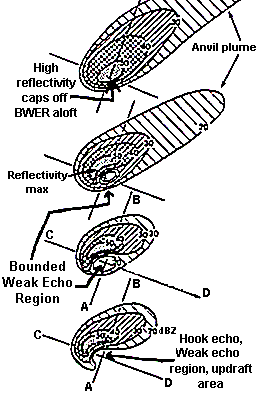
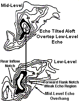
| Plan view of a typical classic supercell as viewed in radar reflectivity data. Bottom (top) picture represents low-level (upper-level) reflectivity. A weak echo region (WER) is noted in low-levels, a bounded weak echo region aloft (BWER), with echo overhang above the BWER overtop the low-level WER (i.e., storm tilt). A large area of light precipitation and cloud extends well downwind in the upper anvil portion of the storm. |
| Low-level WSR-88D Doppler radar image of an actual supercell thunderstorm over north-central Kentucky on May 28, 1996. Dark red color represents very heavy rain and hail. A hook echo is seen on the southwest flank of the storm, coincident with a tornado on the ground at this time. | 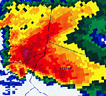
|
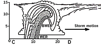
| Vertical cross-section of a typical classic supercell along line C-D in Fig. 4. The x-axis (y-axis) are horizontal (vertical) distance in km. Reflectivity values in dBZ are shown within the storm. The low-level WER, elevated BWER, echo overhang showing storm tilt, and downwind anvil debris clouds clearly are evident. |
Above the WER, a Bounded Weak Echo Region (BWER) (i.e., donut hole) may be present at higher elevation angles (see above figures), indicating overhang in the storm and the location of a strongly rotating updraft. A persistent BWER is associated with a significant mesocyclone.
High reflectivity often caps off the BWER above it. The top part of the storm (echo top) is shifted over the low-level reflectivity gradient or over the WER with possible significant anvil debris extending downwind (see above figures).
Heavy Precipitation (HP) supercells
These exhibit similar features as classic supercells. However, the low-levels frequently show a broad high reflectivity pendent or Front Flank Notch (FFN) (i.e., kidney bean shape) on the leading edge of the storm, indicating the location of the WER and rotating updraft (see figure below). Mesocyclones for HP storms may be embedded in heavy rain. HP supercells are not as isolated as "classic" storms, and often may be embedded within squall lines and travel along boundaries. HP supercells occur in environments with rich low-level moisture and moderate-to-strong wind shear, and are a threat for tornadoes, large hail, damaging winds, and flash flooding. An example of an HP storm embedded within a squall line occurred over south-central Kentucky on May 18, 1995.
| Plan view of radar base reflectivity in the low-levels (bottom picture) and middle-levels (top picture) of a typical HP supercell. A WER is present on the forward flank of the storm in low-levels with echo tilt aloft overtop the low-level WER. Highest reflectivity values in low-levels can resemble a kidney bean shape. |
Classic and HP supercells sometimes can evolve into a bow echo as the rear flank downdraft or a rear inflow jet causes the storm to accelerate outward, resulting in a bowing storm with damaging straight-line winds (see figure below).
| Sequence of basic plan view reflectivity schematics showing how a supercell ("A") can transition into a bow echo storm ("D") due to development of a rear inflow jet and/or intense rear flank downdraft from the HP storm. | 
|
Most severe events occur near the updraft/downdraft interface on the right rear (classic) or front flank (HP) part of a storm. The strongest tornadoes often occur as the BWER begins to collapse.
MESOCYCLONE SIGNATURES ASSOCIATED WITH SUPERCELLS
Mesocyclone: A small-scale solid body rotation closely associated with a convective updraft. True supercell mesocyclones (ones associated with tornadoes, e.g., below figure) must meet or exceed established thresholds for shear, vertical extent, and persistence. For supercells, the following approximate criteria seem to well for Kentucky:
- Shear: Distance between the maximum inbound and maximum outbound less than equal to 5 nm. Rotational velocity Vr = [(max outbound velocity + max inbound velocity) ÷ 2]: Severe thunderstorm warning: greater than about 20 kts (15 kts) if the storm is less (greater) than 100 nm from the radar site. Tornado warning: greater than about 40 kts (30-35 kts) if the storm is less (greater) than 100 nm away. These values are only approximate, so detailed consideration of storm structure, trends, and trained spotter observations are very important as well.
- Vertical extent: Shear extends at least 8,000-10,000 ft in the vertical (but shear may NOT extend this high up for low-top storms or distant supercells that still can cause severe weather).
- Persistence: Coherent rotational signature persists at least 2 volume scans.
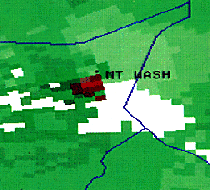
| WSR-88D storm-relative reflectivity image of a tornado-producing mesocyclone near the town of Mt. Washington in north-central Kentucky (southeast of Louisville) on May 28, 1996. Red (green) colors denote radial winds directed away from (toward) the radar located to the west (left) of the area shown. Thus, a tight, cyclonic (counterclockwise) circulation is shown near Mt. Washington. Just northeast of the town, the lighter shaded green color represents storm-relative flow directed into the mesocyclone, which appears to aid in tornado development and maintenance. The mesocyclone is at the same time and position as the hook echo in the previous May 28, 1996 reflectivity image. |
CAUTION: Severe weather and non-supercell tornadoes associated with squall lines and bow echoes may still occur, despite these supercell criteria not being met.
Tornadoes are most likely during the period of maximum mesocyclone core strength. Mesocyclones with the smallest diameters and highest rotational velocities (Vr) extending over a deep layer represent the greatest tornadic threat.
Only about 30 percent or less of mesocyclones that meet supercell criteria produce tornadoes, although most all (90 percent or more) produce some sort of severe weather.
Mature idealized mesocyclone rotational structure in WSR-88D storm-relative velocity data:
- Low-levels: Usually see cyclonic convergence (assuming the storm is close enough to the RDA).
- Middle-levels: pure cyclonic rotation (maximum inbound/outbound are on neighboring radials at the same distance from the radar site).
- Upper-levels: cyclonic divergence. Storm Top: pure divergence (maximum inbound/outbound are along same radial).
Some mesocyclones produce a single rotational core; others produce a series of cores in a periodic fashion. The first mesocyclone core has a relatively long organizing and mature stage. However, subsequent mesocyclones (if any) can develop and mature much faster in the vorticity-rich convective environment, resulting in a series of mesocyclones and a family of tornadoes.
Multiple mesocyclones can evolve as the rear flank downdraft (mini-cold front) accelerates outward and catches up with the forward flank downdraft (mini-warm/stationary front) resulting in a convective-scale triple point occlusion at the mesocyclone/updraft center. Thus, the original mesocyclone weakens while a new one can spin up rapidly at the triple point (see below).
| Conceptual model of mesocyclone core evolution. The "L" shows the mesocyclone location with convective-scale cold and warm/stationary fronts extending from the meso. The cold front is the leading edge of the rear flank downdraft, while the warm/stationary front represents the southern edge of the forward flank downdraft from rain-cooled air north of the boundary. The bold lines are tornado tracks. The insert shows tornado family tracks and the small square in the insert is the region expanded in the schematic. | 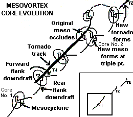
|
The Tornado Vortex Signature (TVS) is a strong, gate-to-gate (adjacent radials on the WSR-88D Doppler radar) shear associated with tornadic scale rotation that meets or exceeds established criteria for shear, vertical extent, and persistence. Identification of a low-level TVS suggests that a tornado may be occurring or may soon develop assuming a favorable reflectivity pattern. However, even without an identified TVS, mesocyclone identification and reflectivity and storm-relative velocity structure is invaluable in assessing the need for a tornado warning.
GUIDANCE FOR WARNING DECISIONS FOR SUPERCELLS
- Always consider as much information as possible, including 1) pre-storm environment; 2) radar reflectivity structure and trends; 3) base and storm-relative velocity, including mesocyclone structure and trends; 4) other pertinent WSR-88D products; 5) storm-scale interactions (within storm environment) causing cell mergers, enhanced shear and rotation, etc.; and 6) spotter reports.
- Do not base a warning decision solely upon mesocyclone strength. Consider the information mentioned above. However, as a rule-of-thumb, if a supercell is identified, including one with only a "weak" mesocyclone, a severe thunderstorm warning should be issued; if a "moderate" or "strong" mesocyclone is indicated and is supported by favorable reflectivity structure and the presence of enhanced low-level storm-relative inflow, a tornado warning should be strongly considered.
- Know conceptual models of storm structure thoroughly. For example, even if velocity data are hard to interpret (e.g., range folding, improper dealiasing, weak mesocyclone at far ranges), but reflectivity structure or spotter reports suggest a severe or tornadic storm, issue the appropriate warning at once.

|  IN-AL-99 |


