< Trough-type Cyclone | Guide to Baroclinic Disturbances | Longwave Lows >
U N D E R C O N S T R U C T I O N
Upper Level Cyclonic Systems
Hybrid-type Storms
“Hybrid-type” storms are so called because they combine the progressive nature of a trough with the energy and abundant upper dynamics associated with closed 500MB lows. There may or may not be a closed contour in the upper level height display. But the extent of these systems is always synoptic-scale, with precipitation and cloud arrays covering a wide geographic area that at some point can cover most of the U.S. as well as portions of Canada and Mexico.
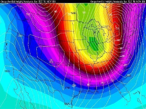
A hybrid disturbance can produce astounding amounts of severe weather, as evidenced by such events as the Nov 15 1989 (see graphic below), April 3 1974, and April 11 1965 outbreaks. Frozen precipitation tends to occur over a lesser time frame, given the tendency for linear advection of vorticity at the upper levels. The hallmark of these storms is the well-defined satellite signature of the cold front associated with the low.
"A Guide to Baroclinic Disturbances" is © 2007 by Larry Cosgrove.
All rights reserved.

|  IN-AL-99 |


